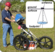
Ground Penetrating Radar is a geophysical method that uses radar pulses to image below the surface. This non-destructive technique makes use of electromagnetic energy in the UHF and VHF bands of the radio spectrum by detecting reflected signals from subsurface structures.
The transmitting antenna of a Ground Penetrating Radar system radiates short pulses of high-frequency radio waves into the ground. When the wave hits a buried object or a boundary with different dielectric constants, the receiving antenna records a variation in velocity and amplitude within the reflected return signal. The principles involved are similar to reflection seismology.
 GPR is employed to characterize and evaluate the internal structure of floors/walls, and the internal steelwork in concrete. The depth range of GPR is limited by the electrical conductivity of the medium, and the transmitting frequency.
High frequencies do not penetrate as far as lower frequencies, but higher frequencies give better resolution. Optimal depth penetration is achieved in dry sandy soils or massive dry materials such as granite, where the depth of penetration is up to 50 feet.
Radar wave travel time is the only direct measurement obtained using GPR equipment in the field. Using an estimate of wave propagation velocity through the ground, the depth (or distance) to buried interfaces or features can be reliably calculated. Often, direct measurements to buried objects are used to calibrate the depth estimates.
Limitations of GPR Technology
There are certain limitations involved with any technology. Radar waves cannot penetrate through metal. Thus, if steel storage tanks are present on the site, GPR will not be able to see inside them, nor assess their condition. Further, objects behind steel may be obscured and thus not observable. Radar performance is driven by the characteristics of the sensor, the targets, and the competing background clutter. An object may be observable at a shallow depth, but the same object may be invisible at a greater depth.
Info@GeoTekServices.com


